The Roberts Point Track
Websites
The Roberts Point Track is now open after the completion of upgrading work. It begins in the Franz Josef Township, at the end of Cowan Street. Alternatively you can pick up the track from the Glacier Access Road via the Douglas Walk.
The track leaves the Douglas Bridge, fords a creek and winds through rata and kamahi forest, before climbing steeply to a shelf high above the Waiho Valley.
Roberts Point track winds up the right of the Franz Josef Glacier Valley, over ice-carved rock and across many side streams to a viewpoint high above the glacial ice. Due to the alpine fault a series of splinter fault lines, separated by up-thrust blocks, cross the upper valley. The track crosses fault lines on man-made galleries and high swing bridges at Arch and Rope Creeks.
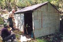
In just over an hour the track opens out onto ice smoothed rock outcrops at Hendes Hut. The hut is unsuitable for overnight accommodation. Hende's Hut was built by Peter Hende for use as a smithy while forming the wrought iron standards to support Hendes Gallery. Since then it has served as a shelter for walkers on the Roberts Track.
The hut is a small corrugated iron hut with a corrugated iron chimney, a doorway but no windows located beside the Roberts Point track.
Historic themes of early tourism and recreation.
Hende was also responsible for the construction of Hendes Gallery adjacent to the hut. The construction, providing access to the glacier, hangs off wrought iron bars driven into sheer rock walls and was restored by the department in 1996.
The track climbs on through open scrubland to a suspension bridge crossing the vast chasm at Rope Creek and steadily upwards passed the point where the ice reached in 1750AD and on to Roberts Point. From Roberts Point the glacier views are truly tremendous with the huge tongue of ice, sheer rock walls, waterfalls beneath high Southern Alps peaks and glacier snowfields.
A challenging day or multi-day tramping/hiking track, you will need a good level of fitness. Sturdy footwear is recommended (i.e. boots). Rocks are likely to be slippery especially after winter frosts or rain. Take warm waterproof clothing and be prepared for all conditions.
Return the way you came. It is dangerous to attempt to climb down from the Roberts Point viewpoint or any other part of the track into the valley.
In heavy rain, side streams can rise rapidly, we advise you do not use the track in these conditions.
Always let someone know where you are going and give an estimated return time. Searches are expensive and time consuming.
Image supplied by the Department of Conservation (DOC).
Are you responsible for The Roberts Point Track?
You can claim this venue to manage this listing's details.
Log in / Sign up
Continuing confirms your acceptance of our terms of service.
Post a comment