Kakepuku Mountain
Website
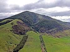
As Kakepuku Mountain emerges from the landscape it is easy to understand how it got its name. According to several accounts the full name of the mountain is ‘Kakepuku-te-aroaro o Kahu’ or the swollen stomach of Kahu. It was so named some six centuries ago by Rakataura, a tohunga of the Tainui canoe. The name referred to the advanced pregnancy of his wife Kahurere (referred to in some accounts as Kahukeke).
An old volcanic cone, Kakepuku features prominently in Waikato history pre Colonial settlement. Tainui settlement in the Kakepuku area began about 1550AD, although there were probably earlier people’s present - notably Ngati Kahupungapunga. Various Tainui hapu have occupied the mountain or its surrounds to the present.
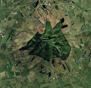
The remains of four pa sites are found under forest canopy or regenerating bush so it is necessary to walk around them to appreciate their extent and features.
A track passes through a fine remnant of original forest in the ancient crater and emerges at the summit itself, where magnificent views of the surrounding Waipa-Waikato landscape reward your efforts.
The reserve is located south of Hamilton between Otorohanga and Te Awamutu off State Highway 3.
Photograph by John Greenwood.
Are you responsible for Kakepuku Mountain?
You can claim this venue to manage this listing's details.


Log in / Sign up
Continuing confirms your acceptance of our terms of service.
Post a comment